1821 Info 9c for Caleb Crompton
The descendants of Elizabeth and Thomas Forsyth
Leslie Milo Forsyth's early life
Leslie Milo FORSYTH was the youngest son of Elizabeth Emily Milner CROMPTON/COX and her second
husband, Thomas Taylor FORSYTH.
18
88
BIRTHS in the District of
Mt Jeffcott Nth
in the Colony of Victoria.
Registered by
Rich. F. Sherwood
No.
CHILD
PARENTS
INFORMANT
WITNESS
REGISTRAR
Where
and
when Born
Name
and whether parent or not
Sex
FATHER
MOTHER
Signature, Description Residence
Accoucher Nurse or other
When
registered and where
Signature of Deputy Registrar
Name, Surname
Rank, Age Birth-place
When and where
married. Issue
Name, Maiden
Surname, Age Birth-place
58
October 20th 1888 Mt Jeffcott North
St Arnaud Shire County Kara Kara
Leslie Milo Not Present
Male
Thomas Taylor Forsyth Farmer
Thirty Three Inverness Scotland
October 12th
1884 St Arnaud Thomas Taylor-Deceased Thomas Crompton 2 yrs
Elizabeth Milner Forsyth
Maiden name Crompton 41 years Launceston Tasmania Former husband
Wm Henry Cox
Thos. Taylor Forsyth
Father Mt Jeffcott Nth St Arnaud Shire County Kara Kara
------
Mrs Strickland
------
November 16th
1888 Mt Jeffcott North
Rich. F. Sherwood
Much of Leslie Milo FORSYTH's physical characteristics have been
gleaned from his army ‘Attestation Paper of Persons Enlisted for Service Abroad’
completed and signed on 13 November 1915 in Ross, Tasmania.
These state that he was born at Mt Jeffcott, Donald, Victoria on 20 October 1888. He named
his mother, Elizabeth FORSYTH of Bayswater, Victoria, as his Next of Kin.
When Leslie signed he was single, 27 years and 1 month old, a blacksmith by trade having
been apprenticed to H.V. McKay Sunshine Harvester Co. for four years and that he had no
previous military service. Leslie was 5ft 7in (1.7m) tall, and weighed 12 stone (76.2kg).
He had a dark complexion, blue eyes and black hair.
Right: Leslie Milo Forsyth in 1912 from the wedding photo of
Mabel Frances BLACKMAN when he was best man to the groom Oliver Otto PEARSON.
Caroline Louisa COX,
his half sister, had married William JT PEARSON, the groom's brother.
The Electoral Roll from 1912 to 1914 shows that Elizabeth Milner CROMPTON/COX/FORSYTH may
have lived in Port Melbourne with Leslie. There are two typographical error - Leslie
Milo and Elizabeth Milner, which may indicate another couple. Thomas Taylor
FORSYTH is not mentioned.
DIVISION OF PORT MELBOURNE,
1912.
SUBDIVISION OF PORT MELBOURNE,
1912
2271
Forsyth, Leslie Mils,
35, Ragland st., Port Melbourne
blacksmith
M
2270
Forsyth, Elizabeth Melna
35, Ragland st., Port Melbourne
home duties
F
1821info9c, sheet 2
Leslie and Elizabeth were recorded at this address until 1914. In 1915, Leslie Mils
(sic) is the sole recorded inhabitant. However, his mother Elizabeth Milner lived in an
unspecified Bayswater property from 1914 to 1925.
35 Raglan Street was, at various times the home of his half sister, Caroline Louisa COX,
Effie CADWELL and WJT PEARSON. It is possible that Elizabeth Milner also lived with
Caroline Louisa and WJT PEARSON at the Woodman Road nursery.
Left: 35 Raglan Street, Port Melbourne, 01 December 2015 Author
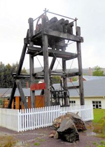
Blacksmithing in Queenstown, Tasmania
Before the First World War, Leslie lived and worked in the copper rich but
isolated west Tasmanian town of Queenstown. He may have had to take a steamer from
Launceston to Strahan's Macquarie Harbour before boarding the Abt railway to
Queenstown to take up his trade as blacksmith. Geoffrey Blainey, in his book The
Peaks of Lyell, records that the
proverbial blacksmith's shop sprang up besides a score of new tunnels,
if only to sharpen and temper the boring chisels. However, Penghana, a mile up the
railway from Queenstown was the site of the original Mt Lyell blacksmith workshops,
until it was burnt to the ground in the bush fire of 12 December 1896. The passages
below will give a flavour of Leslie's experiences.
Right: A map locating Queenstown, Tasmania
It is likely Leslie was employed by the
Mount Lyell Mining and Railway Company 1 (MLMRC). On 22 May
1903, James Crotty's North Lyell Company (registered September 1897) and the Mount Lyell
Mining Company merged to form MLMRC. The North Lyell Company had a good mine with good quality
ore, but it was being poorly developed and managed and its smelters were a failure. The Mount
Lyell Mining Company had only a mediocre low-grade mine from the original Iron Blow excavation,
but its eleven pyritic smelters were perhaps the best in the world. Blainey (ibid), comments that
miners would remain there just long enough to earn their
fare back to the mainland. However, following the 1912 fire industrial harmony and
affluence prevailed in the copper fields. The photos below show illustrate scenes that Leslie
may/would have seen during his work.
1821info9c, sheet 3
Hoverbox Photo Gallery - Mount Lyell copper workings
1. Mount Lyell's open cut mine, undated
2. Mount Lyell's eleven smelters 29 June 1902
3. Mount Lyell's Cos smelter c.1900, Beattie State Library of
Victoria H92.300_245
1
2
3
Although the Electoral Roll shows Leslie living in Allan's Lane, volunteers in
Queenstown's Galley Museum (see below) were, after extensive research, unable to find
Allan's Lane or any mention of Leslie. They think that as the miners cottages were placed
randomly on the hills that Allan lived at the bottom of the Lane. The Electoral Roll suggests
that Leslie returned to the same address after the war and before his marriage in 1920. This is
doubtful. The photograph below shows Bachelor Street is to represent Allen's Lane, though at
a post-World War 1 date.
Blainey (ibid), describes miner accommodation at the turn of the century. Although Leslie was
there twelve years later, some of the accommodation may still have been seen in the townships.
The insanitary conditions remained until 1995.
'At first most men lived in small hillside huts, erected by their
mates in Sunday working bees. Even in 1901, when houses were rapidly replacing huts, 1,100 of the
2,900 habitations in the district were single-roomed huts, and another 700 houses had only two
rooms. In the same year, males predominated by almost two to one, and by an even higher ratio in
Gormanston, where gales and rain and creeping mist made miserable the days of the housewife. As
the women increased, the shanty suburbs gave way to small houses with red or tarred roofs. The
main street of Queenstown, already packed with solid shops and two-storied hotels, wore an
impressive façade when the three-stored brick hotels - the "Empire" and the "
Imperial" - sprang up by the railway station to greet wealthy investors.
In the first years they were insanitary towns, scourged by typhoid and
dependent on frequent rains to wash away the refuse. As there were few acres of arable land on
the west coast, fresh vegetables and fresh milk were luxuries. In 1898 two cows grazed in the
district, and tinned milk was the vogue. Despite the high rainfall water was often scarce. At
Gormanston running water was often impregnated with copper, and miners complained that sulphur
fumes contaminated tank water.
DIVISION OF DARWIN (1914)
SUBDIVISION OF QUEENSTOWN (1914)
688
Forsyth, Leslie Milo,
Allan's lane, Queenstown
blacksmith
M
The area of what was to become the first Mount Lyell settlement was soon pegged out, and a
shanty town, Penghana, grew up in the Queen River valley. It was burnt out in 1896 and the
settlement, renamed Queenstown, moved further down the Queen River, though still dominated by the
then Mount Lyell Mining Company. Queenstown boomed. By 1901 it was Tasmania's third-largest
town, with 5051 people, fourteen hotels, banks, schools and shops. It soon gained electric street
lighting, provided by the Company's Lake Margaret power scheme. In the 1954 edition of his
book Blainey (ibid), describes Queenstown as
The heart of the town retains the [the frontier town] atmosphere of the
1890's, though new public buildings have been built in recent years. When Orr Street, the
narrow main street, is quiet or deserted, it resembles the old mining towns of the wild west of
the United States, with the quaint locomotives and the old Pullman observation cars in the
five-track railway yard, hundreds of wooden veranda posts stretching in unbroken line on each
side of the road, shabby old-fashioned shops of wood and iron, and a background of razorback
hills and stark mountains walling in the town. This antique air persists on Saturday evenings in
summertime when the silver band plays from a hotel balcony or the highland band parades the
streets, while people line the road and pavement.
1821info9c, sheet 4
The population rose and fell in succeeding years, as mining's fortunes varied and large
machinery gradually displaced manual workers. Queenstown continued to be a major town with
population statistics being 5293 in 1903, 3827 in 1911 and 3216 in 1921. Tree-felling, sulphur
and fire denuded the surrounding hills of trees, giving Queenstown its 'moonscape', but
the mines brought prosperity and, as well, more militant workers than elsewhere in Tasmania,
strong unions, and a close-knit community. [...] but Queenstown remained remote, without direct
transport connections with the rest of Tasmania. It wasn't until 19 November 1932 that the
through Hobart to Queenstown road opened. Five years later a road connected Launceston to
Queenstown. (Blainey (ibid))
3. Hotels in Orr Street, Queenstown - 1895
4. Queenstown Post Office - 24 August 1897
1
2
3
4
Sulphur was the curse of Mt. Lyell. When the big company smelted its
pyrite in ten or eleven large furnaces Queenstown found its climate changing. In still weather
sulphur from the smelters thickened fogs into invisible pea-soupers, choked Queens-town, and
blanketed the valley. For days on end men working in the flux quarries on the hills above the
town basked in the winter sun, and looked down on the creamy waste of cotton wool in the valley.
Men who set out with hurricane lamps for the smelters in the morning were sometimes found miles
away at evening. Sulphur was in every breath of air; even tobacco lost its taste. One holiday
procession became hopelessly confused when marchers split in different directions at a fogbound
corner.
On clear days passengers on ships sailing into Macquarie Harbour could
see the sulphur pall of the Mt. Lyell smelters, hovering over the rugged mountains, fifteen to
twenty miles away. The few travellers who walked overland from Hobart saw the corroded iron
telegraph poles, ten miles before they reached Linda. At the Mt. Jukes mines, seven miles from
the smelters, miners tasted the sulphur when the wind was northerly. The prevailing
souwesterlies blew the fumes to Gormanston, but Queenstown fared worst in fogs or northerly
winds.
The second curse was rain. In 1906 1.422m of rain fell in 79 wet days in
a three month period. Today 2.408m of rain fall in the 336 cloudy days of the year.
The Mount Lyell fire
Leslie was in Queenstown at the time of the Mount Lyell Fire. It is possible that he saw the
funeral train.
The fire began between 11:15 and 11:30 am Saturday 12 October 1912 in a pump house on the
700-foot level of the Mount Lyell mine, as 170 miners were working on six underground levels of
the North Lyell shaft. Initially there was no panic, as it was believed that once the King Billy
pine which lined the pump house was destroyed, the fire would burn itself out and not spread to
the wet, heavy timbers which supported the roof of the drives. Only 73 men made their way to
safety on the first day. The next shift even entered the mine, confident that the fire would soon
be extinguished.
Considerable problems occurred evacuating those who were still alive. There was no emergency
warning system. Instead, men had to run along the levels and drives warning the men of the serious
danger that faced them. Many became trapped as they were working in remote stopes and didn't
know of the fire until it was far too late.
But deadly carbon monoxide fumes meant rescue work was delayed until appropriate clothing and
apparatus came by a record-breaking mercy dash by rail and steamer from Victoria's mines.
Fifty-one men were finally rescued from the 1000-foot level on Wednesday morning and 42 lives
were lost. The bodies were buried in unmarked graves in the Queenstown General cemetery.
1821info9c, sheet 5
Despite rumours of incendiarism, a Royal Commission could not detect the cause of the fire: an
open verdict remained.
Leslie declared a 5% gas disability as a result of being wounded by a gas shell on 10 April
1918. He may well have been affected by the large quantities of sulphur dioxide and nitrogen oxide
emissions spewed out by the smelters, These gases mixed with the 2.4m (95 inches) of annual
rainfall to form acid rain
that denuded the landscape 2. Even today vast tracts of land are like a
vegetation less, orange moonscape. This would have been the landscape Leslie saw, though the
Queen River was a biologically dead from the smelters, chemical tailings and human sewage.
Hoverbox Photo Gallery - Pollution - Author:
14 November 2015
1. Acid rain denuded landscape, undated
3. Despite the clean up a recent photo of Queen River
2. Denuded moonscape on the road out of Queenstown to
Gormanston 14 November 2015
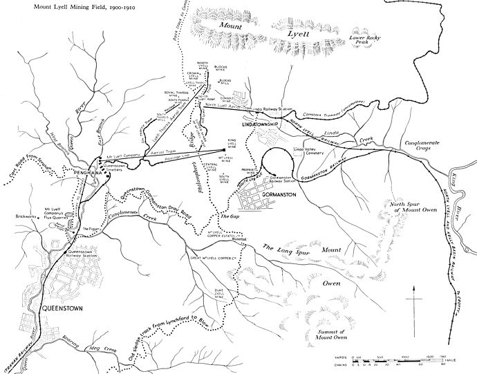
Above: Mining environs of Queenstown, c.1900 to 1910
Source: Blainey (ibid) Click on the map to open a 256kB A4 landscape map in a new window
1821info9c, sheet 7
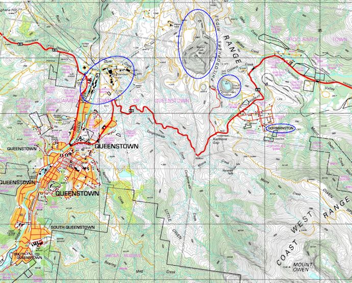
Above: 1:250000 map of the modern Queenstown area showing
many of the original and historic copper features Click on the map to open a 256kB A4 landscape map Source:
The LISTmaps (Accessed: 10 April 2016)
Above: The map shows
The location of Queenstown the Mt Lyell town and Gormanston, the North Lyell town
Philosopher's Ridge, where the first prospecting took place
In the decade of the 1870s, a discovery by one man tramping alone in the West Coast
wilderness in the summer of 1871 profoundly changed the history of the West Coast and of
Tasmania. The man was James 'Philosopher' Smith and his discovery was the
fabulously rich Mount Bischoff tin deposits, soon developed to the richest tin mine in
the world. In the years that followed, other prospectors who penetrated this wild and
uninhabited country found almost every known mineral of value to man — gold, silver,
copper, tin, iron, lead, zinc, wolfram, osmiridium and others — and the West Coast
mineral province became Tasmania's richest natural resource.
Queenstown, situated in the rugged west coast hills, was born when Cornelius Lynch found
gold in the area in 1881. Many diggers arrived, though the trip from the harbour at
Strahan up the King River was extremely difficult, and the land journey worse through
almost impenetrable bush.
Michael and William McDonoughs and Steve Karlson battled their way up the dark, heavily-
forested King River Gorge, much of it already pegged by this time, and deeper into the
high mountains of the West Coast Range, reaching the foothills of Mount Lyell in November
1883. There, camped in the area on Philosophers Ridge between mountains of the West Coast
Range, in the Linda Valley they found fine gold shed from a thick ironstone mass, known
as the 'Iron Blow'. They examined the strange formation. It jutted twenty or
thirty feet above the surface and was split by deep cracks and crevices as if a great
explosion had fractured the rock and flung slabs far down the hill...(they)... had seen
no similar outcrop in their brief mining experience. Pegging a claim and tracing the gold
bearing material to the eastern flank of a ridge connecting Mount Lyell to Mount Owen,
they worked the alluvial gold by sluicing the slopes. Others followed, though development
was expensive and difficult, due to isolation and poor access through thick scrub.
They believed Iron Blow was the capping of a rich gold reef — the mother lode of the
alluvial gold being found in the rivers and creeks of the West Coast Range. Bill McDonough
eagerly tramped the 100 miles back to Waratah and the nearest mines office to register the
claim. The McDonough brothers and Steve Karlson thus became the discoverers, not of a rich
gold mine as they believed, but of the huge Mount Lyell copper field.
The Iron Blow had been discovered and pegged in 1883 but it was not until the decade of
the 1890s that the great Mount Lyell copper mine it covered was brought into production.
By then the McDonoughs and Karlson, disillusioned with their unprofitable 'gold
mine' had sold their shares for a few pounds, rolled their swags and gone their
separate ways, still in search of the elusive yellow metal. They never found it.
James Crotty, another of the early Macquarie Harbour prospectors, acquired Mick
McDonough's one-third share by paying Mick's £20 (about £2 200 at 2014 RPI
inflation index) debt at FO Henry's Strahan store. In less than 15 years that one-
third share was worth some £1 500 000 (more than £16 483 214.55 at 2014 RPI inflation
index).
In 1886 FO Henry, J Crotty and W Dixon formed the Mount Lyell Gold Mining Company and an
8- head stamp mill started crushing ore at the Iron Blow. But, recoveries were poor. In
1892 two Adelaide financiers, Kelly and Orr, realising that a fortune in copper was being
washed down the sluice boxes, bought the mine and the Mount Lyell Gold Mining Company was
formed in 1889. By now, 28 companies were working the field.
In 1891 a big, burly Broken Hill investor and one of the wealthiest men in Australia,
Bowes Kelly, became by far the major shareholder in the Mount Lyell Gold Mining Company.
He was encouraged by FO Henry to ride overland to the Iron Blow, still being prospected
by James Crotty. After sending an experienced metallurgist, Herman Schlapp, to further
assess the deposit, Kelly promoted the first Mount Lyell Mining Company in Melbourne in
January 1892, with the issue of 100 000, £1 shares. Kelly got 20 000 shares and his two
main partners, investor William Orr and metallurgist Schlapp, got 15 000 and 10 000
respectively. Within a few months of the opening of the Mount Lyell mine in 1897, the £1
(£110 at 2014 RPI inflation index) shares were worth £16/10/- (£16.50) (£1 813.15 at 2014
RPI inflation index).
After several ups and downs the Mount Lyell Mining Company was liquidated and the Mount
Lyell Mining and Railway Company was established on 29 March 1893, mainly producing
copper. As the surface gravel, soil and button grass were sluiced away, in 1893 a pyrite
ore body was exposed. Within the main mass were richer patches, one of spectacular grade
which provided the impetus for the rapid development of underground mining. The following
year the Mount Lyell Bonanza produced over 850 tons of high grade copper and silver ore.
Profit enabled more development, including an Abt railway from Strahan in 1896. In 1895
Robert Carl Sticht arrived as chief metallurgist and perfected pyritic smelting.
1821inf09c, sheet 9
More information 1:- cont
In addition to his 3000 share in the Iron Blow, James Crotty discovered rich ores were
on the eastern side of the shoulder and pegged three separate 10-acre leases of his own.
One of them became the North Lyell mine, far bigger and richer in copper than the Mount
Lyell Company's Iron Blow deposit.
Crotty formed his own North Mount Lyell Copper Company (North Lyell Company) with capital
raised mainly in London and Glasgow and set about creating his own empire to duplicate and
rival the Mount Lyell Mining Company — mine, smelters, railway, port, ship and towns.
Crotty could probably have made just as much money, by a merger but chose instead to
spend millions duplicating the Mount Lyell Company complex.
The North Lyell Company rivalled Mount Lyell. It completed the railway, port and smelters
and spared no expense. At least £! 250 000 (£137 360 121.2555 at 2014 RPI inflation index)
was poured into the North Lyell enterprise: a vast sum for those times and twice the
capital expenditure of the Mount Lyell Company. North Mount Lyell had richer ore than the
Mount Lyell Company, but its new furnaces failed.
At the turn of the century, the Lyell copper field had two major mines, two smelters, two
railways, two ports. By 1901, the new townships of Queenstown, Gormanston, Crotty,
Pillinger, Lynchford and Linda with a population of more than 10 000, were flourishing.
Sticht had eleven blast furnaces working in the smelting plant. The Mount Lyell company
operations centred mainly on the shoulder between Mount Owen and Mount Lyell, and to the
western side of the mountain. On the eastern side of the shoulder were the old North Mount
Lyell workings, where the 1912 North Mount Lyell Disaster occurred.
The telling difference between the rival companies, however, was that the Mount Lyell
Company was being superbly managed by an American metallurgist, Sticht, whose success in
the pyritic smelting of the Mount Lyell copper ore had earned him international acclaim
in the mining industry. The North Mount Lyell Copper Company was being badly mismanaged
by a succession of appointees of a London-based company whose directors had never even
seen the mine. The North Lyell Company had a good mine but it was being poorly developed
and its smelters were a failure. The Mount Lyell Mining Company had only a mediocre low-
grade mine but its smelters were perhaps the best in the world.
Both companies could have saved enormously by blending their ores and smelting in the same
furnaces. A worried Mount Lyell Mining Company made initial merger approaches at the close
of the century. The approach was bluntly, and foolishly rejected. By 1902 both companies
were facing bankruptcy and merger negotiations were resumed, finally signing an agreement
on 22 May 1903 to form the Mount Lyell Mining and Railway Company. With the original Mount
Lyell board retaining the real power, it meant the end of Crotty and Pillinger.
In 1914 the Company built its own hydro-electric power scheme. In 1922 the Iron Blow, now
a vast open cut, was phased out, leaving underground workings to supply the ore. Its
copper contained many impurities, and from 1928 further refining by electrolysis produced
copper 99.8 percent pure. From 1934 to 1972, the West Lyell mine produced 47 million tons
of copper ore.
In 1963 the Abt railway to the Macquarie Harbour port of Strahan closed, as maintenance
costs were high, while road transport was easier. Economic problems saw the closure of the
refinery in 1964, and the smelters in 1969 when the Mount Lyell smelters closed and the
company began exporting its ore as concentrates to Japan. In 1976 depressed copper prices
forced the retrenchment of almost half the workforce. The Mount Lyell Mining and Railway
Company, now a subsidiary of Renison Goldfields Ltd, suffered continuing problems and in
1993 work stopped at the mine. Twelve months later it was taken over by Gold Mines of
Australia, but low copper prices made the operation unviable, and it was sold to an Indian
company, Twin Star Holdings. They used the ore for smelting operations in India, and in
2004 employed about 270 people.
The Mount Lyell mining operations produced more than a million tonnes of copper, 750
tonnes of silver and 45 tonnes of gold since mining began in the early 1890s: equivalent
to over $4 billion worth of metal in 1995 terms.
Source: Tasmanian History - Mount Lyell (Accessed: 10
June 2017)
Pink, Kerry, ‘Through Hells Gates – A History of Strahan and Macquarie Harbour’, Gordon
River Cruises, Strahan, 2010
Blainey, Geoffrey, 'The Peaks of Lyell', Melbourne University Press, 1959
1821info9c, sheet 10
More information 2
Queenstown pollution
In the early years of the mining boom the King River was likened to a miniature Gordon —
the same dark waters reflecting the cloak of rainforest along the banks of the river. To
the early prospectors the forested King River Gorge and the deep waters of the lower
river were a nightmare, but when the Mount Lyell mine began production the King River was
its first port. Before the railway was extended to Strahan a port operated at Teepookana
and small steamers traded daily from Strahan to the King River and the seven miles (11 km)
upriver to Teepookana. The scenery was magnificent.
For decades the King River was renowned, not for its beauty, but for precisely the
opposite. It was the ugliest river in Tasmania and probably the worst example of
industrial pollution in Australia. For more than 50 years the once splendid river was an
industrial and human sewer.
The King River remains biologically dead [...]: a slimy, yellow and grey gutter lined with
dead trees — an ecological disaster.. Nothing grows along its banks and nothing lives in
its waters. Its once deep valley is clogged with millions of tonnes of waste from the
Mount Lyell ore concentrating plant and raw sewage from Queenstown. About 1 500 000
tonnes of mine tailings and 5 000 000 gallons of raw sewage were discharged every year
into the Queen River at Queenstown and carried nearly 32 km into the King River and
Macquarie Harbour. [...] Surveys in the 1980s indicated that perhaps 75 per cent of the
harbour bed was covered by silt, and at the mouth of the King River, the silt was tens of
metres thick.
Sulphur was the curse of Mt. Lyell. When the merged company smelted its pyrite in the
eleven large furnaces, Queenstown found its climate changing. Between 1916 and 1934 the
mine's sintering plant had been pumping sulphur into the air. This only stopped when
the sulphur was converted to agricultural superphosphates.
Until 1995 tonnes of sulfidic tailings entered the river system each year, along with huge
volumes of acidic, metal-rich water flowing from the workings. When it was in operation,
the fumes from the ore smelter produced acid rain which also leached minerals from the
bare hills of Queenstown. This acid mine drainage was an environmental tragedy — killing
the bird and fish life in the river and harbour and the once towering forests and
abundant vegetation along its banks.
[In 1954] near the smelters [stood] the monument to the vanished era of direct smelting —
a great black slag dump, more than sixty feet high, half a mile long and covering forty-
three acres of the valley. The bare, coloured hills, stripped of all trees, shrubs and
peat until only the skeleton of bedrock remained, also stand witness to the era when
clouds of sulphur drifted over the smelters. Although the new method of treatment checked
the sulphur scourge, allowed gardens to flower, and tallow-wood, cheesewood, dogwood and
small green shrubs to fight their way back on to the more sheltered ranges, it painted a
new scar on the landscape. Tailings from the twenty-six million tons of pulped ore that
passed through the mill have turned two rivers into grey industrial gutters, silted up
the beautiful lower reaches of the river where the barges glided up to Teepookana, and
formed a long spit in Macquarie Harbour.
The problem of raw sewage from Queenstown ended when more than A$2 million of the Federal
Governments A$276.5 million compensation package provided to Tasmania for the loss of the
Gordon-below-Franklin Hydro Electric Company power development was spent on a sewage
treatment plan for Queenstown.
In 1992 the King River was dammed above the confluence with the Queen River to generate
hydroelectric power, affecting the way tailings were transported through the river system
and the water quality. Tailings ceased to be deposited from 1995 with the closure of the
mine however, acidity in both the King and Queen rivers remains a problem and dissolved
metal concentrations continue to be highly toxic to aquatic life. While treatment options
continue to be investigated and new technologies applied as part of its ongoing
remediation, the King retains its reputation as arguably Australia's most polluted
river.
Strahan people acknowledge and give credit to the historic contribution of the Mount Lyell
copper mine to the economy of the West Coast and Tasmania. But some believe the cost to
past and future generations — the death of the King River and the siltation of Macquarie
Harbour — was too high a price to pay.
Source: Blainey. Geoffrey, 'The Peaks of Lyell', Melbourne University Press, Melbourne,
1959
Pink, Kerry, ‘Through Hells Gates – A History of Strahan and Macquarie Harbour’, Gordon
River Cruises, Strahan, 2010
This page was created by Richard Crompton
and maintained by Chris Glass