1821 Info 1c2: Caleb Crompton
His life in Van Diemen's Land - finding 'Springdale'
Early attempts to locate Spring Dale Lake River
For some still unknown reason Caleb's letter of 30 November 1845 was in the possession of my
grandfather, Arthur CROMPTON. Grandma Jane then passed it on to my father and eventually it came
to me. It was this letter and the availability of the internet, that started my search for Caleb
and his descendants.
On 13 April 1966 my uncle, Edmond Thomas CROMPTON of 1660 Russell Road, Ottawa 8, wrote to Mr P Eldershan, the State Archivist in Hobart, enclosing a photocopy of Caleb's letter and asking for
the return of the 'three other letters' enclosed. He asked:
for the location of the farm at 'Spring Dale' (now known to be Spring Vale)
and the date it was acquired by Caleb;
whether the land had been subsumed as part of an urban development;
for the date of Caleb and Fanny's death and place of burial.
By writing 'Spring Dale' in 1966, Uncle Ted didn't know how close he was to the truth. However,
without the aid of computer databases, Hobart Archives replied to say they were unable to trace
Spring Dale or any land owned by Caleb CROMPTON. They added 'Therefore it seems fairly
unlikely that he did not actually own this land but only leased it.' No mention was made of
the Spring Vale alternative.
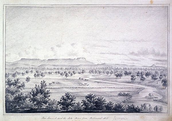
Above: Ben Lomond and the Lake River from Richmond Hill
Creator: Emily Stuart Bowring 1835-ca. 1912 Unsigned and undated. Pencil on paper;
23 x 34cm. Date: c.1856 Source: LINC Tasmania in:
Sketchbook of Tasmanian scenes The search facilities access
photographs of rivers, mountains, landscapes and history of Tasmania. (Accessed 07
August 2015)
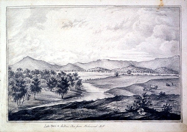
1821info1c2, sheet 2
Above: Lake River Western Tier from Richmond Hill Creator: Emily Stuart Bowring 1835-ca. 1912 Unsigned and undated. Pencil on
paper; 23 x 31cm. Date: c.1856 Source:Opt cit LINC Tasmania in: Sketchbook of Tasmanian scenes (Accessed 07 August
2015)
Later, Launceston Reference Library suggest that the homestead of Spring Dale was along Lake
River, south-east of Cressey, but Spring Dale did not appear on modern maps. This information
clarified Caleb's home address, written as Spring Dale NO COMMA Lake River, as Spring
Dale COMMA Lake River. Additionally they said:
A hand drawn survey map, from the 1830s, list many farms and homesteads in the
area, but not Spring Dale. There is property/locale known as Spring Bank situated on the
eastern banks of some spring-fed swamps a few miles due west of Longford. About the same
distance north east of Longford is a spot named "The Springs".
It has been suggested that Spring Dale was a police post, but there is no evidence
to support this.
Lake River was once part of the Van Diemen's Land Company's holding.
1821info1c2, sheet 3
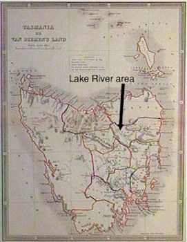
The geographical location of Lake River, Tasmania
Originally and in Caleb's time, Lake River joined the
South Esk River is near Evandale, 12½ miles (20km) south-south-east of Launceston. The
Macquarie River was its tributary
Today, Lake River is only so-called from its origins in the south, to its union with the
Macquarie River near Longford - a modest stretch of some thirty-odd miles. The first 15
miles (24km) of the southern reaches of Lake River remain to this day, inaccessible by
track - there are none. The main centres are Longford, Cressy and Evandale.
Lake River is a meadow stream, flanked by flat pasture, grassy basins and backwater
lagoons.
Intensive cropping, aided by river irrigation, takes place on the reddish-brown to grey-
brown friable clays. Grazing supplies the Longford abattoir.
The region formerly know as Lake River was re-christened to Pisa around 1900. Pisa remains
as a southern township, though that is a most flattering description of the outpost.
Above: The lake River area within Tasmania
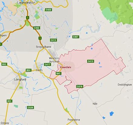
Left: Map locating Evandale district, in relationship to Launceston and
Longford, in 2015
1821info1c2, sheet 4
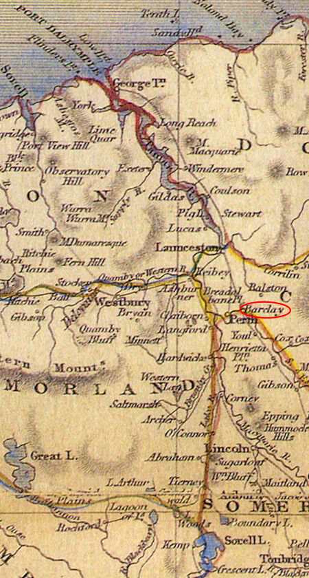
When Tallis drew his map in 1851, the Macquarie River was
still a tributary of Lake River. Evandale, 6½ miles (10.4 km) east-north-east of
Longford, was not included as it was not incorporated as a town until 1866. It would be
located at the settlement marked as Barclay - circled red.
Perth (marked Perm) was the registration district where Caleb's first daughter
Maralena was registered and Longford was where his second daughter Elizabeth Emily Milner
was registered.
Right: An abstract from John Tallis' 1851 map of Van Diemen's Land showing the
Lake River and Launceston areas Click on the image to open an A4, 2.16mB, Tallis' map of Van Diemen's Land in a
new window
1821info1c2, sheet 5
David Young's investigations to find 'Spring Dale' in Hobart LINC, September
2015
David Young was commissioned to clarify Caleb's position in Van Diemen's Land. He
reported, with reference to Launceston Archives Office, LINC Tasmania Ref: CS08/1/164 P150
(see 1821info1b):
On arrival Caleb was employed by Mr MANNING of Evandale, which is close to the old confluence
of Lake River and South Esk River. This was Mr Thomas MANNING. However, a Mr Frederick MANNING,
properly called Mr Frederick MANING, owned a 'bush block' to the south. The investigation
was to find whether Caleb worked for Mr Thomas MANNING or Mr Frederick MANING?
When Caleb arrived he was initially employed by Mr MANNING of Evandale. However, J.H.
Hughes' 1837 survey map of Tasmanian land grants - see below -shows no Mr Manning (with
two 'n's) registered as a land owner in the Evandale area.
However, Hughes shows land belonging to Mr MANNING as a 'bush-block' of between 200
and 300 acres (81-120ha) on the same latitude as Campbell Town and between the western
slopes of Mount O'Connor and Lake River. This block actually belonged to Mr Frederick
MANING, who, on 17 April 1833, had sold 3060 acres (1240ha) to C Swanston.
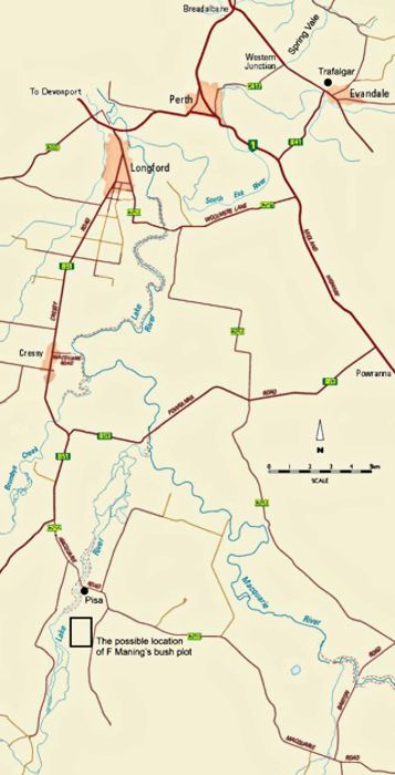
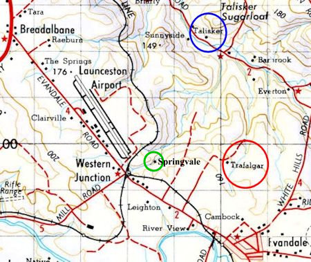
Right: The Lake River's drainage basin, settlements, roads and the the location
of Evandale and the MANNING bush-block. Click on the map to open a 64kB A4 image in a new window
Note 1: In Caleb's day the Macquarie River was a tributary of Lake River. Lake
River flowed into the South Esk.
Note 2: The location of Trafalgar - see later - is shown in the north-east corner.
Note 3: Frederick MANING's bush-block is located in the south-west corner of the
map and below highlighted in purple.
1821info1c2, sheet 6
David Young, having researched F MANING, concludes:
Frederick MANING, whose name is more often spelled ‘Manning’,
though the man himself seemed to favour a single n, sold 3060 acres to C Swanston on 17 April
1833. He obviously retained some land there, because of the block of somewhere between 200 and
300 acres shown on Hughes’ map [see above left], and the fact he is described in his 1862
Will as being ‘late of Lake River’ (Wills book 8 no. 720). MANING retired to Sandy
Bay, then as now an upmarket Hobart suburb, at some time in the 1850s, dying there on 12 June
1864 at the age of 76 (Mercury, 13 June 1864).
MANING had very strong business interests in Hobart, which would have
kept him there. I don't think that he would have trusted a distant farm to an unknown young
migrant, even if he was a Yorkshireman. [Nor do I] believe that he would ever have been described
as 'Mr Manning of Evandale', when he never lived in the town or closer than 35km from it.
David Young was pretty sure that Thomas MANNING, the Evandale farmer, was the man whom Caleb
worked for from 1843, and that we can eliminate Frederick MANING from the story. The main
reason behind his thinking is that:
Thomas was an Evandale resident and a farmer, his name was spelt with two 'm's;
Caleb was much more likely to find his future wife, on the McLeod property of Taliskar,
from Evandale than a bush-block miles from anywhere; and
Evandale was within easy reach of Launceston (where Caleb got married) whereas Frederick
MANING's bush-block was not.
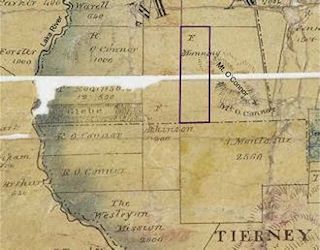
Above: Map of the area north of the South Esk, Van Diemen's
Land, surveyed by J.H. Hughes 1837
1821info1c2, sheet 7
In red, Barclay land, some of which was tenanted by Thomas Manning, possibly Caleb's
first employer;
In green the land of RP Stewart who may have been a relative of William
Stewart/Stuart, Frances' step-father.
Positions of dwellings are approximate.
Click on the map to open an enlarged A4 portrait 194kB map in a new window. Source:LINC Tasmania
(Accessed: 04 August 2015)
He continues:
Thomas MANNING was a tenant farmer on a large Evandale property called
Trafalgar. Prior to that, he appears to have been a pound keeper on Norfolk Plains (Launceston
Advertiser, 20 September 1832 p298c1). In 1846 he leased two farmlets on Trafalgar, one of
171 acres (69ha) and one of 174 acres (70ha). The leases expired in that year, and it is unclear
whether Thomas renewed them (Launceston Advertiser, 15 August 1846 p4c3). He certainly remained at
Trafalgar, possibly still on a farm, possibly in a smaller rented cottage, for that is
where he lived when he died in 1851 at the age of 64 (Cornwall Chronicle, 8 November 1851 p714c4).
His widow, Sarah, was still living on the Trafalgar property when she died two years later.
It is this that makes me think that the Mannings might have relocated to a rented cottage on the
property rather than a farm (Cornwall Chronicle, 2 November 1853 p2c3).
In David Young's opinion Caleb resided at Trafalgar or on the Trafalgar
estate.
On 22 June 1831, the eight year-old [Frances] Louisa LOMBE was 'indentured' to Mr Stuart
(sic) at the residence of
Major [Donald] McLeod for the amount of £6 (six pounds or £535 in 2018). Major
McLeod lived at Talisker, a farm in the valley of the Rose Rivulet, 2.5km across
the fields from Trafalgar. Placing Caleb at Trafalgar means that it is easy
for him to meet, court and later marry Frances.
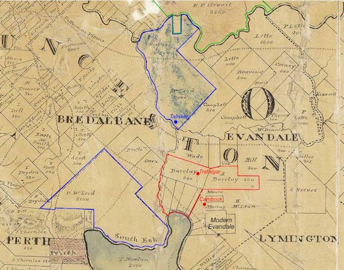
Left: A modern map locating Trafalgar and Talisker farms and the town of and
Evandale. Note the close proximity of the Trafalgar and Talisker land.
Notes
Other LINC Tasmania sources: to locate Spring Dale
Settlement map Epping to Evandale LSD 264/1/8 - negative
Landowner map - Evandale area-approximately Epping to Evandale LSD264/1/8 01 January 1836
- negative
Map - Cressy, in vicinity of Brumby Rivulet showing landholders. 01 January 1858
LSD264/1/17
- negative
1821info1c2, sheet 8
Trafalgar and Spring Vale - LINC Launceston
On 10 November 2015, in a LINC Launceston interview with archivist Steve Pearsall, it was
deemed very possible that Caleb's location was actually Spring Vale, of which Spring Vale
Creek is the permanent water supply for the Trafalgar land. It was deemed acceptable, despite the
very clear use in the letter of 'Dale', that Caleb had mis-written the name, perhaps using
the familiar Yorkshire dialect 'dale' for 'vale', there being only one letter
different. Or, it was again acceptable that the name changed between the time of Caleb's
letter and the visitation of John Richardson GLOVER.
It was deemed acceptable, at this
present time, that Caleb and Frances lived at the Spring Vale settlement on the land of
Trafalgar.
'After an extensive search of Trove we have not found any evidence to suggest there
was ever a property at the Lake River named Spring Dale, nor have we located any evidence
that Caleb CROMPTON owned or rented property in the Lake River area'. - Steve Pearsall
The Longford 1845 and 1848 census and jury lists for Caleb's time at Lake River have
not survived.
Spring Vale was close to Frances' work place of Talisker.
Spring Vale was close to York Street Baptist Chapel in Launceston, where their marriage
took place.
Maralena was register in Longford with Caleb's home being given as Perth, which is the
correct area for a Longford registration.
Page 46 of John Richardson GLOVER's Sketchbook of Evandale describes Spring Vale
as:
'... part of of Andrew Barclay's Trafalgar Estate, became the site of the
first tunnel designed to take water from Evandale to Launceston. A convict station with
accommodation for convicts, guards and supervisor and engineers were on the property.'
Major McLeod, of Talisker, is reported to be commanding convicts.
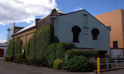
Caleb's marriage to Frances Lombe
Caleb was married at York Street Baptist Church, Launceston on 14 July
1844 to Frances Louisa LOMBE (Fanny). Fanny's brother William was a witness.
Right: York Street Baptist Chapel taken in 1995. There was a note attached to
the picture saying: "former Baptist Chapel". This is self-evident from the
picture. In 2015 this was a Chinese take Away at 113 York Street.
Victoria Pioneer Index:
14 Aug 1844 Caleb aged 24 Frances aged 22
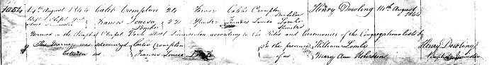
1821info1c2, sheet 9
1844 MARRIAGES in the registration district of
LAUNCESTON
No.
When Married and where
Name and Surname
Age
Rank
Signature and Description of Parties
Name of Clergyman
When Registered
Signature of Officiating Minister
1054
14th August 1844 Baptist Chapel
York Street Launceston
Caleb Crompton
24
Farmer
Caleb Crompton Bachelor
Henry Dowling
14th August 1844
Henry Dowling
Frances Louisa Lombe
22
Spinster
Frances Louisa Lombe Spinster
Married in the Baptist Chapel, York Street, Launceston
according to the Rites and Ceremonies of the Congregational lists, by Henry Dawling,
Vicar
This marriage was{Caleb Crompton
solomnised between us{Frances Louisa Lombe
In the Presence { William Lombeof us { Mary Ann Robertson
Above: Caleb's Marriage certificate Ref: LINC
Tasmania RGD37/1/3 no 1054 Click on the image to open a full size A4 image in a new window
For sometime after Caleb's letter to his mother the farm must have
been successful as . On 19 July 1848 Caleb sailed to Port Adelaide "exporting"
his produce on board the brig 'Henry' (107 tons, AF Farley master) and perhaps
again on 4 September 1848, this time exporting 17 bags of oats. These trips suggest that
Caleb and his family may have been frequent travelers between Launceston and Adelaide.
The Archives Office of Tasmania records Caleb's journey at POL220/1 p10. Here he is
also referred to as a 'free passenger'.
Whilst at Spring Dale, Maralena Louisa was born on 06 July 1845 and Elizabeth Milner on 31 June
1847.
Above: A composite image of Maralena Crompton's birth
certificate Ref: LincTasmania RGD33/1/27 no 612 Click on the image to open a full size A4 image in a new window
Note: LINC Tasmania record Maralena as Madalena
Above: A composite image of Elizabeth milner Crompton's
birth certificate Ref: LincTasmania RGD33/1/27 no 842 Click on the image to open a full size A4 image in a new window
Scenes of early Trafalgar and Trafalgar in the 1920s
John Richardson GLOVER (1790-1868), the eldest son of the famous landscape painter John GLOVER,
landed in Van Diemen's Land in 1831, with his father. He visited and sketched Trafalgar and
Spring Vale. The remaining black and white photographs were taken by the Hart family. With kind
permission of the 2015 owner, Trevor Couchman.
Trafalgar is a Permanently Registered Listed building on the Tasmania
Heritage Register, number THR:5317. It is an early brick two-roomed cottage built before 1820 as
temporary accommodation before the main house was constructed several years later. It
characterises the single storey brick Old Colonial Georgian rural domestic building. The main
house is now long gone, while the original brick house remains (though weatherboard additions
cover three sides of the structure). Barclay continued acquiring land in the surrounding district
and by 1828 was considered the largest owner of good land on the island. He died in 1839. Several
roads such as Barclay Street, Cambock Lane and Trafalgar Lane mark his influence on the area.