|
 |
| Above: Emily Crompton circa 1955
Right: William Howland Smith circa 1955 Source: Family photographs |
1808 Info 4b for William Crompton
|
A tribute to Emily CROMPTON and William Howland SMITH, whose legacy lies in the land.
|
|
| Above: Emily Crompton circa 1955
Right: William Howland Smith circa 1955 Source: Family photographs |
Mary's illegitimate daughter, Emily, was born on 07 May 1873 (GRO ref: Driffield 9d 279).
| REGISTRATION DISTRICT DRIFFIELD | ||||||||
|---|---|---|---|---|---|---|---|---|
| 1873 Birth in Sub-district of Driffield in the County of York | ||||||||
| No | When and where born |
Name | Sex | Name of father |
Name of mother |
Rank or Profession |
Informant | When Registered |
| 203 | Seventh May 1873 Nafferton |
Emily | Girl | Mary Crompton |
Mary Crompton Mother Nafferton |
Twenty eighth May 1873 |
||
Emily left home to become a domestic servant at Hill Farm, Carnaby where the family then lived.
1891 Census   Sun/Mon 5/6th April 1891
Source:       FHL Film  PRO Ref RG12
              Piece: 3959; Folio: 5; Page: 6; Sched:
Dwelling:     Hill Farm
Place:        Carnaby, York, England

Name               Rel  Mar Age  Occupation           Birthplace
John Granger       Head  M  69   Farmer               Yorks, Cranswick
Marianne Granger   Wife  M  50                        Yorks, Driffield
..
Emily Crompton     Serv  U  17   Dom. General servant Yorks, Driffield
| Right: Hill Farm, Carnaby 2010 |  |
Later, Emily worked for Cicely Boynton and Thomas Lampugh Wickham at Burton Agnes Hall. Here she met William Howland SMITH who was a gardener for the Boyton-Wickhams.
In the fourth quarter of 1896, under the name Emily CHAPLIN, she married William Howland SMITH (GRO ref: Bridlington 9d 703). William, from Leeds, was born 07 May 1869 (GRO ref: no obvious record). The couple still lived in Burton Agnes at the time of the 1901 census.
1901 Census   Sun/Mon 31st March/1st April 1901
Source:       FHL Film  TNA Ref RG13
              Piece: 4522; Folio: 29; Page: 16; Sched: 93
Dwelling:     [School House]
Place:        Burton Agnes, Yorks ER, England

Name            Rel  Mar Age  Occupation         Status  Birthplace
William Smith  Head   M   30  Shepherd           Worker  Yorks, Leeds
Emily Smith    Wife   M   27                             Yorks, Nafferton
There are no William Howland Smith's registered in Leeds or the West Riding between March 1870 and December 1872. There are eight William Smiths born in Leeds during the same period.
Whilst living in Thornholme 1 two sons were born: Arthur William SMITH on 15 September 1902 (GRO ref: Bridlington 9d 361) and Harry SMITH on 16 October 1909 (GRO ref: Bridlington 9d 345 or 350).
1911 Census:      Sun/Mon 2nd April/3rd April 1911
Source:   TNA Ref:        RG14 PN28888
          Reg. Gen. Ref:  RG78 PN1662; En.Dist: 2; Sched: 37
          RegDist: Bridlington SubDist: Skipsea
Dwelling: [Second cottage on left when entering from Bridlington - Winter's Farm]
Place:    Thornholme, Burton Agnes, Yorkshire East Riding
Rooms in dwelling, other than scullery, landing, lobby, closet, bathroom: 4
Years married: 14
Children:      Alive 2, dead 2

Name             Rel Mar Age  Occupation            Status  Birthplace
William Smith   Head  M   40  Farm Labourer         Worker  Yorks, Leeds
Emily Smith     Wife  M   37                                Yorks, Nafferton
Arthur Smith     Son       8                                Yorks, Thornholme
Harry Smith      Son       1                                Yorks, Thornholme
Family hearsay recalls that Emily lost two daughters with in a month:
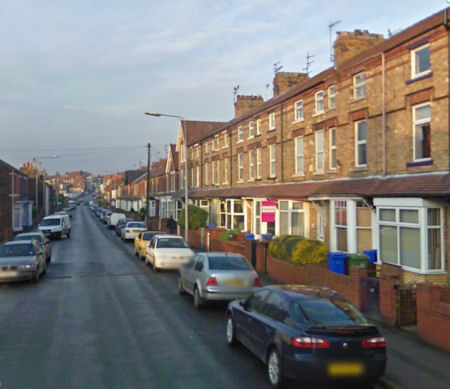
| At sometime between the census of 03 April 1911 and 17 October 1911, when Frank was
born, the family moved to Brookland Road, Bridlington. William worked for the
gas board whilst Emily, using her skills from Burton Agnes Hall, ran the family home as
seasonal seaside bed and breakfast accommodation.
This row of three storey bay windowed terraced houses is a convenient 0.8 miles (1.3km) from the station and 1 mile (1.68km) from the sea front. It is easy to imagine the family living on the top floor whilst the guests took the ground floor and the first floor bedrooms. Left: Brookland Road, Bridlington 2009 |
 |
1921 Census:      Sun 19th June 1921
Source:   RG15;  Piece: ;
          RegDist number: 526; SubDist: 2; ED 3; Sched: 241;
          Reg District: Bridlington;  Parish: Bridlington
Dwelling: 65 Brookland Road
Place:    Bridlington, Yorkshire East Riding
Rooms:    6
Children under sixteen: 2

Name                     Rel    Age  Mar  Occupation       Employer  Work place  Birthplace
                               Yrs Mn
William Smith           Head   53   1 M   General Labourer Bridlington Gas Company  Yorks, Leeds
Emily Smith             Wife   48   1 M   Home Duties                               Yorks, Nafferton
Herbert A Sowresland  Lodger   48         Piano tuner      Friend & Co Bridlington  London
Harry Shortt          Lodger   53         General Labourer Out of work              Yorks, Beverley
William Moor          Lodger   49         General Labourer Builder Bridlington      Yorks, Bridlington
Harry Smith              Son   11  8  BL                                            Yorks, Thornholme
Frank Smith              Son    9  7  BL                                            Yorks, Thornholme
Arthur Trowell   Nurse child    5     BL                                            Yorks, Wakefield
Whilst living in Bridlington, the children went to Burlington School, Marton Road and Harry, the only smoker, worked as a wages clerk for the railway.
 |
| Above: A map showing the movements of Emily and William around the Bridlington area |
Tithe Farm, Lissett
Arthur had always wanted to be a farmer and the 1921 Census shows he had left home and was a 'horseman' on an unknown Lissett Farm.
1921 Census:      Sun 19th June 1921
Source:   RG15;  Piece: 23861;
          RegDist number: 526; SubDist: 1; ED 3; Sched: 21;
          Reg District: Bridlington;  Parish: [Skipsea]
Dwelling:
Place:    Lisset, Yorkshire East Riding
Rooms:    6
Children under sixteen: none

Name                   Rel    Age  Mar  Occupation  Employer  Work place    Birthplace
                            Yrs Mn
Henry Wilson           Head  26  5  M   Farmer      Employer  At Home       Yorks, Barmston
Florence Grace Wilson  Wife  23  2  M   Home Duties           At home       Yorks, Keighley
Arthur Smith           Serv  18  9  S   Horseman              Henry Wilson  Yorks, Thornholme
Thomas Claxton         Serv  16  8  S   Horseman              Henry Wilson  Yorks, Bridlington
Robert Ward            Serv  15  9  S   Head Stockman         Henry Wilson  Yorks, Snainton
Charlotte Coymer       Serv  13  7  S   Kitchen maid          Henry Wilson  Yorks, Skipsea
| Between 1921 and 1931 the family moved to Tithe Farm at the end
of Tithe Lane, Lissett.
Right: 1893 OS map showing Tithe Farm Scale 1:10580 |
 |
At the time of the 1911 Valuation Survey, R Wright farmed the 139.5 acres (56.5 hectare) of glebe land, the benefice of Rev. GW Trevor of Beeford Rectory, at an annual rent of £ 180(equivalent to £10,271 in 2005). The farm was described as a ' compact farm, 13 acres of grass, remainder arable, fairly good strong land, live fees, no timber, good water, few fruit trees.'
The buildings, 'in fair repair' and valued at £700 equivalent to £39,942 in 2005), were constructed of brick with tile or slate roofs. Two wooden covered fold shed, built by the tenant, were deemed 'worthless' . Although the map, detailing the location of the buildings, is missing the written details classify them as:
| A | Cottage, 2 bedrooms, kitchen, wash house, pantry, coals | B | Cottage, 4 bedrooms (2 v. small), kitchen, room, dairy, coal house | C | Hen house, 2 bay cart shed |
| D | Wood oven , implement shed | E | Box, stable 5, granary over | F | Barn |
| H | Box, cowshed (5), 4 bay fold shed | K | Covered fold, 7 bay | L | 4 bay fold shed |
| M | 3 bay fold shed |
It is not known which of the two cottages were the family home.
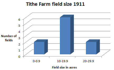 |
Left: A graphical representation showing the break down of the 139.5 acres
into field size Source: The National Archives, Kew (TNA) IR 58/73670/220 In 1911 the value of 'other things growing on the land' was £175 (equivalent to £9,985 in 2005). The market value of the farm, divest of structures produce, was £3,290 (equivalent to £187,727 in 2005). The ' machinery' value was not listed. This small acreage allowed William and Emily to gain a start with their own farm. |
In 1930 Emily and William were given the opportunity to leave Tithes Farm to move to Auburn Farm.
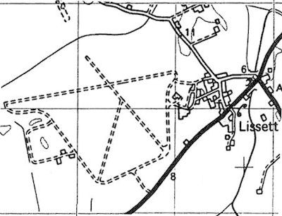
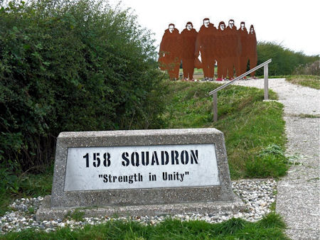
In 1942 RAF Lissett was constructed on the meadowlands of Tithe Farm. The map below shows that the 1400 yards (1280m) runway 15-33 ended close to the farm buildings. It was first occupied by 158 Squadron of heavy bomber on 28 February 1943.
 |
| Above: A map of the RAF Lissett runways on an 1893 ordnance map showing Tithe Farm in the top left |
Auburn Farm, Fraisthorpe
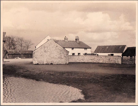 |
In 1931 Emily and William moved to the cliff edge Auburn Farm in the
parish of Fraisthorpe (YO15 3QU) near Bridlington.
The pond shown in the bottom left of the photograph was filled in around 1959-1960 Left: Auburn Farm circa 1955 Source: Diane Witt, family photograph |
| Source: Auburn Farm gate flickr | 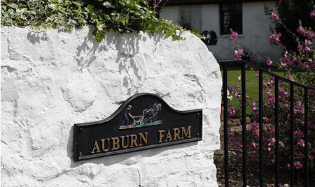 |
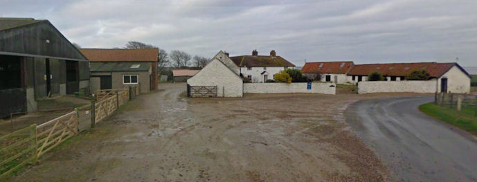 |
| Above: Auburn Farm and stock buildings in 2008, showing it to be little changed from the 1928 map |
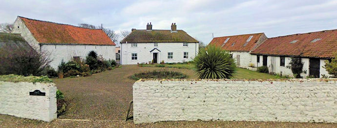 |
| Above: Author Auburn Farm house and fold yard in 2008 |
An introduction to Auburn Farm in history
'Because of the low-lying and heavy nature of the land, much of the parish was from early times used for pasture and meadow, and the economy of the parish has always been pastoral. ... Meadow land lay mainly along the streams. ... By circa 1716 the whole parish [of Fraisthorpe] had been enclosed, and there [was] ... one holding in Auburn. ... In 1841 there were ... one farmer and one cottager in Auburn. The number of farmers in each township has changed little. ... Always one in Auburn ... of 150 acres or over.' 2
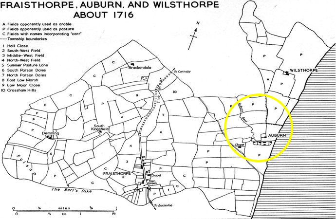 |
| Above: A 1716 map of Auburn Source: VCH p.200 |
Auburn Farm at the time of the 1911 Valuation Survey
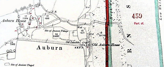 |
| Above: Auburn Farm on the 1888 OS 1911 Valuation map,
showing, in red characters, building use Source: TNA IR 134/05/150 |
In 1911 the 16 fields of 273 acres (110.5 hectare), tenanted by Messers FH & Henry Hyde, had an annual rent of £330. It is unlikely that the nature of the buildings changed in the subsequent twenty years. The property was described as a 'Farm house, 4 bedrooms, 2 kitchens and 2 living rooms, barn, granary, stables, sheds and 4 roomed hands house (falling down) [Old Auburn House].'
A breakdown of the out buildings around the fold yard, valued at £900 (equivalent to £51,354 in 2005), suggests a combination of brick, iron, wood and tile. There was a heavy emphasis on horses but with space for the war time tractors. However, any implements on the farm were not separately valued.
| A | House | B | 2 boxes, stable 2, 3 bay shed box | C | 3 bay fold shed, box |
| D | Stable 10 | E | Stable 3, cowshed 7, turnip house, 2 calf houses | F | 3 bay implement shed, fold shed |
| H | Hen house, implement shed | K | 6 bay cart shed, granary over | L | Covered fold, implement shed |
| M | 3 bay fold shed | N | 2 bay cart shed | O | 4 roomed cottage |
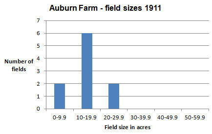 |
Left: A graphical representation showing the break down of the 273 acres
into field size Source: TNA IR 58/73668/83 In 1911 the value of 'other things growing on the land' was £300 (equivalent to £17,118 in 2005). The market value of the farm, divest of structures produce, was £6,550 (equivalent to £373,743 in 2005). If the farm buildings, described in 1911 as 'All in bad condition' reflect the state of the farm, then WH SMITH and Emily had much to do. |
Auburn Farm at the time of the National Farm Survey 04 June 1941
At the time of the National Farm Survey (NFS), on or about 05 September 1941, William Howland SMITH had been named the full time farmer-tenant of the Boynton Estate Trustees for ten years. However, Arthur W SMITH was quoted as the occupier. For farming the 274 acres a rent of £365 was paid (equivalent to £10428.80 in 2005). In giving the farm an overall classification of 'B' the War Ag's surveyor, WW Gatenly, made the general comment that:
'This farm has been much improved by the present tenant but poor drainage in many of the arable fields has a great effect in reducing production.'
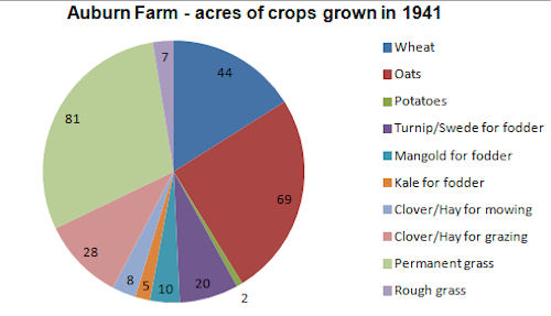
Whilst 50% of the farms soil was classified as medium, 20% was light and 30% of the soil was heavy clay. In the opinion of the surveyor this and the poor drainage, restricted the natural quality of the farm to being 20% 'good' and 80% 'fair'. However, no infestations of animals or plants were recorded.
During the War 55% of the farm was arable and 45% grass. It is thought that the:
|
 |
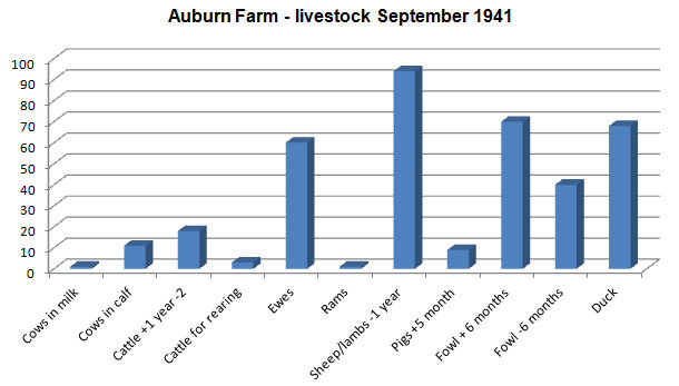 |
The list ofAuburn livestock would suggest that:
|
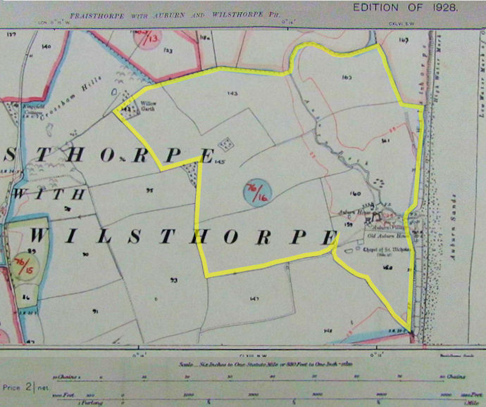 |
| Above: A composite map of Auburn Farm at the time of the 1941 survey, marked yellow and referenced 76/16. At the time of the map survey Auburn Farm's fields were merged with those of Manor Farm Source: TNA MAF 73/47/146 |
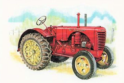 |
The NFS records that motive power on the farm was provided by two mares and four
geldings. In addition there were two 'wheel tractors for field work': a 27 horse power
Massey Harris Pacemaker and a 30 horse power Oliver 80 Standard.
Left: Massey Harris Pacemaker 1936 |
| The Oliver 80 Standard was rated as a three plough tractor, powered by an
advanced overhead valve engine available in both petrol and kerosene fuelled versions.
Transmission was via four forward and one reverse speed gearbox. Maximum speed in high
gear was 5.6 m.p.h. at 1,200 r.p.m. The Oliver 80 was a well constructed and high-quality
tractor with renowned reliability and a long working life.
It is likely that these tractors were provided by the Government's Lease-Lend scheme. Imported from the Americas, they were given to farmers to replace the dominance of the horse and to improve the wartime production. The Government intended for the farmers to buy the tractors at the end of the War. But, in 1945 there were so many tractors that they were virtually given away. |
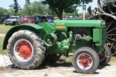 |
| Above: Oliver 80 Standard 1937 |
1939 England and Wales Register 29 September 1939 ED Area code: JCD ED District code: S Sched no: 154 Dwelling: Auburn Farm Borough,UD,RD: Bridlington, East Yorkshire Names Sex D of B Status Personal Occupation Others Smith William H M 07may1868 M Arable Farmer Smith Emily F 07may1873 M Unpaid domestic duties Smith Harry M 16oct1910 S Arable Farmer Smith Frank M 17oct1912 S Arable FarmerKingSmith Esther F 14nov1911 S Domestic Servant Dunnington Leonard M 25mar1919 S Horseman on Farm Robinson Douglas M 13feb1915 S University Student Short Hildred M 07nov1867 S Incapacitated Dent Arthur A S 28nov1887 M Accountant International
The National Identity Number devised from this Registration would have been: Enumeration Area
code+Emuneration District code+Schedule number+position in house
Names were ruled through because the Register was kept up to date until 1953 and
married name
added because the Register was kept up to date until 1953.
This applies to Esther King/Smith, a domestic servant, who married Harry on 28 October 1939.
Auburn Farm in the Second World War
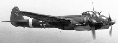
'On 15th August 1940 many Luftwaffe aircraft were in the process of attacking Driffield when this one was shot down by a Hurricane pilot and crashed near Auburn Farm, close to the cliff top near Fraisthorpe to the south of Bridlington. Although it contains a number of incorrect assumptions a witnesses account for this incident has been located in the Civil Defence File for the Bridlington area. A Mr Smith, of Auburn Farm, Fraisthorpe was quoted in the report "On 15th August 1940, at about 1 pm one aircraft with two engines came in low over the farm. It was shot at by a single "Spitfire" which gave a quick burst then flew off towards Barmston over the sea. The bomber seemed to gain height in a starboard turn and black smoke issued from both engines. He turned and headed for the farm. He turned to starboard and dived into the ground.
 |
The wreckage was scattered over the other side of
Earl's Dike. One engine went into the next field. The crash was
in a cornfield. All the crew were killed.'
Left: A 1942 Junkers JU88 3 variant, similar to the one shot down near Auburn Farm |
Further research has found that one of the crew, the wireless operator, had attempted to bale out at low level but his parachute caught in the tail of the aircraft and he was dragged down and killed when the aircraft crashed. The other three crew were believed to have been still inside the aircraft when it struck the ground. The resulting explosion killed all three instantly and it was only after careful investigation that their remains were located. Only the observers body was identified from these three airmen and all three were buried in separate graves in Bridlington Cemetery with that of another Luftwaffe airman killed on this date. After the War their remains were taken to the large German cemetery at Cannock Chase. However, the pilot was then identified and buried under his correct name. The fourth member of the crew's body was never identified and he is technically recorded as missing. His remains must also have been taken to Cannock Chase but they are not buried with the other three members of his crew.
| This Junkers Ju88 was shot down by P/O Donald S Scott RAF (40569) flying a 73 Squadron
Hurricane [based at Church Fenton]; not a Spitfire as the witness quoted above believed."
Right: A Mk 1 Hurricane in 73 Squadron colours |
 |
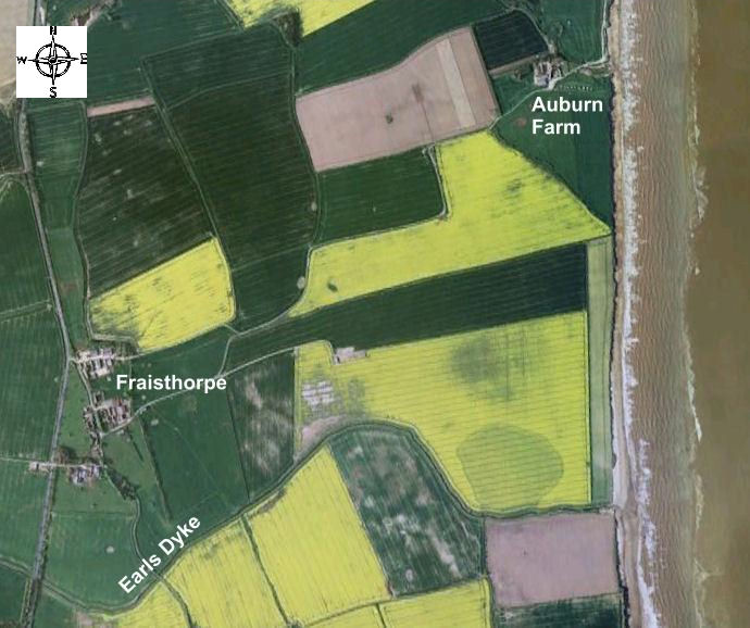 |
| Above: An aerial view of Auburn Farm and Earls Dyke in 2012.
William Smith's account would suggest the plane crashed in the area of the coastal brown field. |
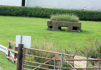
| Auburn Farm was also at the forefront of the defence of Britain. William
and Emily must have been inconvenienced by the construction of the anti-invasion beach
defences along Auburn Sands, which probably coincided with the 1941 demolition of Old
Auburn House. The coastline was a very vulnerable, quiet area, perfect for a German
landing. Here the coast consists of smooth, golden, flat, sandy beaches and gently
shelving sands backed by low boulder-clay cliffs, with flat tank country behind it. Today,
it is a perfect example of surviving 'coastal crust' defences and most definitely worth a
visit.
Right: Pill box next to Auburn Farm |
 |
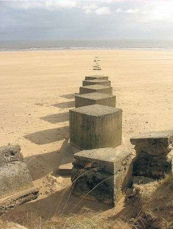 |
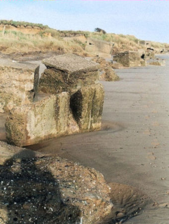
It is still possible to see how the length of the beach was sub-divided into areas by
transverse rows of anti-tank cubes that extend out beyond the low tide mark. The cubes,
some of which have initials and dates (1941) inscribed into them, are roughly 1.2m square
in plan and vary in height. These created controlled fire areas, so the defenders could
'manage' the invaders into abattoir-style killing zones. If the defence design worked, the
invaders would have been massacred by devastating enfilading fire from the locally
designed 'eared' front-entrance death trap pillboxes, firing at an angle up and down the
beach.
Left: Anti-tank cubes at Auburn Sands Source: Tim Denton |
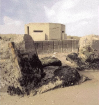
| The more substantial ‘eared’ pillbox were generally set at the rear of the
beach, permitting enfilade (flanking) fire in support of the ‘lozenge’
pillboxes, trenches and beach defence lights nearby. They were designed to house two
Vickers medium machine guns in the sustained fire role, and unlike the ‘
lozenge’ type, it does not have a 360° field of fire. The design of the
‘eared’ pillboxes is unusual in having two wide-splay embrasures, one in each
flanking wall; the wall bulges out beneath the embrasure sill to allow for water cooling
cans for the guns, and they are entered by two forward facing 'to the last man' doorways.
These pillboxes were only used as part of the coastal crust defences and are only found
on or overlooking beaches. Due to the nature of the glacial tills, the foundation rafts
for these pillboxes were often built to massive proportions, an example of which can be
seen at Auburn Sands where coast erosion has left the structure marooned on the beach.
Right: An 'eared' pillbox at Auburn Beach |
 |
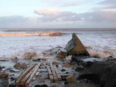 |
The base of the coastal slope was obstructed by a variety of means, possibly
indicating alterations and additions over time; these include concrete anti-tank walls,
corroded stubs of scaffolding obstacles, slipways and linear rows of anti-tank cubes. The
inscription on one cube sums up the attitude of the time: 'They shall not pass'.
Left: Coastal defence slipway at Auburn Farm |
 |
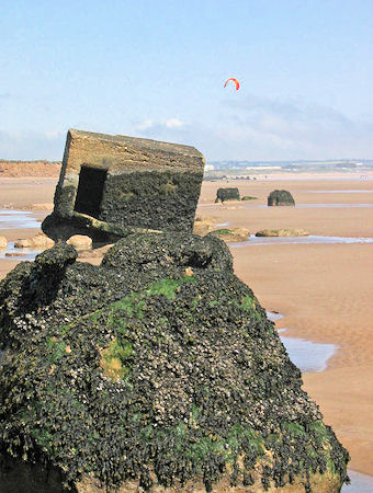 |
| Above and right: Coastal defences now showing the erosion of Holderness | Above: Stephen Horncastle in Images from the Geography British Isles project |
End notes
Sources:
Auburn Farm in 1968
On Thursday 12 September 1968, at 3-30pm, Jackson-Stops of York auctioned the Fraisthorpe Estate at the Bell Hotel, Great Driffield. WH Smith and Sons were the tenants of 287 acres (116.144 hectares) at a rent of £1875 (equivalent to £24112 in 2005) per annum, paid yearly on 06 April. The family went to the auction with the intension of buying but were more than disappointed when bids exceeded their limit. The estate was purchased by an investment company with the Smiths remaining tenants.
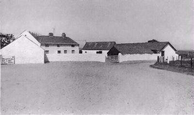
| The house was described as being directly served by a County road from
Fraisthorpe to a 'commanding position by the coastline, with home pastures running up to
the sand dunes on a broad frontage'. Improvements had taken place since 1941. 'The neat
appearance is most impressive, the brick elevation of the house and immediate buildings
being freshly white-washed. Mains electricity and water had reached the farm.
Right: Auburn Farm 1968 Source: Diane Witt family photograph |
 |
The accommodation, mostly built of brick with a pantile roof, was on two floors and included a cloakroom and WC to cesspool drainage. The living room had an open fireplace, with the sitting room and drawing room with a modern tiled fire place. The kitchen was fitted with a modern combination range and sink unit. There were 4-5 bedrooms and a modern bathroom and WC on the upper floor.
The land also appears to have been much improved. It was described as ring fenced enclosures with productive soil yielding cereals, fodder crops and good grass affording 100 acres (40.46 hectares) of permanent pasture and 176 acres (71.22 hectares) of arable. This suggests that, since 1941, an extra 11% of the farm had been brought into arable, possibly through improved drainage. 1
 |
| Above: Author House and fold yard at Auburn Farm in 2008 |
RT Jackson and Sons
In 2012 Auburn Farm and Manor Farm remain in William's family as RT Jackson and Sons.
Coastal erosion at Auburn
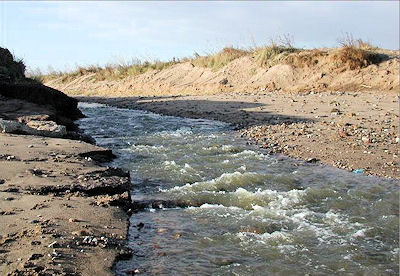
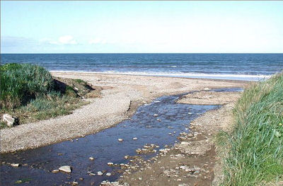
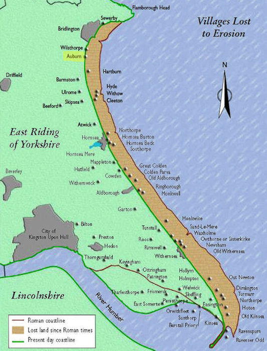
It has been estimated that when the Romans were in Britain the East Yorkshire coastline of Holderness was about three and a half miles (5.632km) further east than it is now. When the Domesday Book of 1086 gave the first full list of settlements, the coastline was probably about two miles (3.218km) further east than today's position. Now twenty two Holderness villages 2 each with their church, farm houses, cottages, mills and ponds lie under the sea off the Holderness coast as the boulder clay cliffs crumble and retreat. Auburn was one such village. Its location is now only marked by a farm of that name and the remains of St Nicholas' Chapel. 'Most of the encroachment took place before 1850.' 3
| Right: Map locating the lost village of Auburn 4
|
 |
Thomas Sheppard described Auburn and its coast when he wrote:
| For many years the township of Auburn was constantly assailed by the sea, its site being now some distance from the cliff edge, and covered by about 16 feet (4.9m) of water at high-water spring tide. When the last building of the village was reached, and part of it was washed away the sea seemed to stay its work, sand-dunes were formed, and though I have been familiar with "Auburn House" for nearly a quarter of a century, it does not change at all, and the part remaining has been bricked up and inhabited. A few months ago, a slight change in the position of one of the sand-dunes a little north of Auburn House, revealed a fragment of the old coaching road to Beverley, most of which is now washed away. ... 5 | 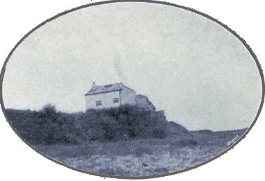 |
|
| Above: Auburn House circa 1912 Photo by J Hollingworth |
... On Tuke's map of 1787 and in papers and books there are scores of measurements from fixed points near the coastline to the cliff edge. In recent years [1912] these were remeasured. [The average erosion from Bridlington to Spurn Point is 7 feet (2.13m) per annum, at Hornsea the average is 4 feet (1.22m), Withernsea 9 feet (2.75m) and at Kilnsea 6 feet (1.8m)]'.
The decline of Auburn village
When my great, great grandma, Frances HARPER was born at Auburn House and christened on 25 September 1815, the village had been abandoned to coastal erosion, except for a farm and a cottage. St Nicholas chapel had been dismantled in 1731. In 1857, the chapel and the remains of the village shown on the map, were described as:
'Auburn or Aborn was formerly a chapelry in the parish of Fraisthorpe but the village has been reduced by the encroachments of the German Ocean [North Sea] to one farm of about 200 acres of land and a cottage situated 1 miles NE from Fraisthorpe. The Living of Auburn is a Perpetual Curacy endowed with £600 from Queen Anne's Bounty. On the 25th of September 1731 a faculty was granted to take down the Chapel of Auburn, when it was likely to share the fate of the rest of the village and by a license dated Dec[ember] 20th in the same year, the Curacy of Auburn was annexed to that of Fraisthorpe.' 6
The church of St Nicholas, Auburn, was taken down around 1590 because it stood very near the sea and was rebuilt inland on Auburn Common. In 1605 it was said to be in need of repair as 'the end of the chapel where the bells rings is under propped'. In 1720 it again needed restoration but repairs were neglected so that in 1731 it was 'scarce fir for public use', this state of affairs being attributed to depopulation. Consequently, under licence from the archbishop, it was demolished the same year. A mound and the foundation walls mark the site. The Norman tub font, with chevron ornamentation, was transferred to Wragby church (Yorks, W.R.) 7
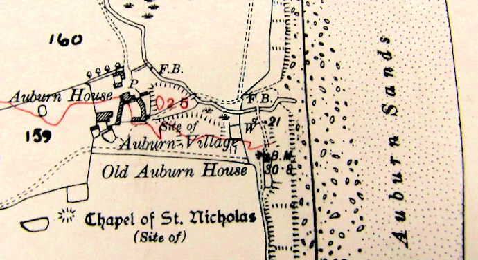 |
| Above: A 1928 map of Auburn Farm and its immediate surrounds
Source: TNA: MAF 73/47/146
Click on the map to open an A4 landscape map of the whole farm edged in blue and labelled 76/16 |
The Victoria County History reports:
'By about 1716 there were seven houses and a chapel. In 1731 only three houses remained and the chapel was demolished the same year. By 1823 there was only one occupied farm house, along with a small cottage in the township. ... Old Auburn House, which was already near the edge in 1850, was demolished in 1941 (H[arry] SMITH interview 1969), but its foundations were still visible on the edge of the cliff immediately south of the beck in 1968. Earthworks in a field adjoining the cliff, south of the beck, mark part of the site of the village, and the site of the chapel is indicated by a small mound about 150 yards south-west of Auburn House [Farm].'
'The decline of Auburn may have begun with the Black Death for its tax quota reduced by 55 per cent in 1354; it was a very beggarly village in 1571. ... By 1674 there were 15 households and in 1764 there were twelve. The population of Fraisthorpe and Auburn together was 87 in 1801 and 103 in 1831. ... There were twelve inhabitants in Auburn in 1841.' 8
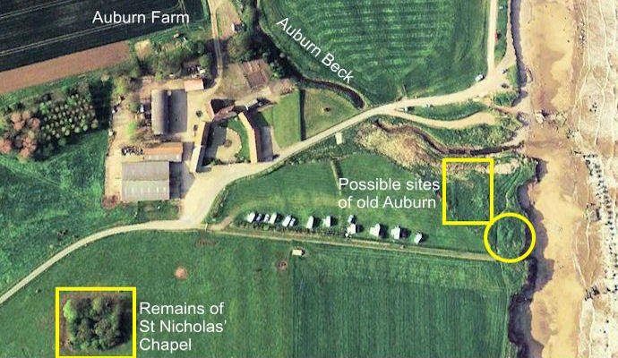 |
| Above: An aerial view of Old Auburn remains 2011 |
| Frances HARPER, though married and living in North Newbald in 1841, may
have been one of few inhabitants of Auburn in 1831, when aged 16, According to the 1851
census she was born in Auburn House, one of two buildings standing in 1823.
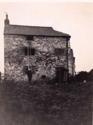
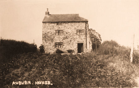
By 1968 there was only one house in the ancient village, Auburn House Farm, which stands about 200 yards from the shore. It is an 18th century building of cobbles, with out buildings of the same material surrounding a fold yard in front of the house.' 9 'When the Smith's moved to Auburn, Uncle Arthur set up a shop in the cottage, selling sweets and drinks to the public on the beach.' Right: Auburn House after 1936 and before the 1941 war time demolition. Note that parts of the right hand wall have disappeared. Source: Diane Witt family photograph |
 |
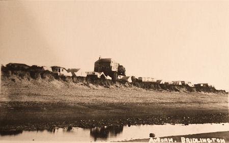
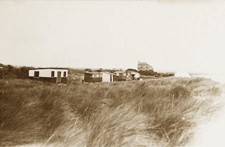
Hoverbox Photo Gallery - Postcards of Auburn House before 1939
This feature does not function correctly on phones and tablets
|
| 1 | 2 | 3 | 4 |
|---|
|
|
|
|
Auburn Sands today
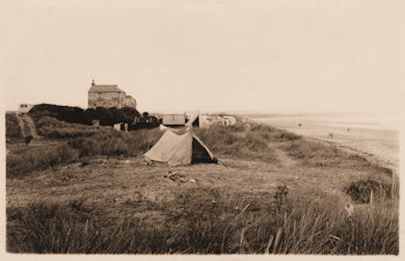
Auburn Sands is a designated bathing beach in the East Riding. It is described as a sandy beach with low clay cliffs behind, which offer shelter from the wind. The sands are clean, with pools around the bases of old anti-invasion defences. 'Good swimming and ideal for children'. There are no facilities on the beach itself. 'Toilets may be available at the nearby farm' and there is a small charge for the car park, which is open till 9:30pm. The sands are flat and expansive. The tides go a long way out, so at low tide there really is a massive expanse of soft sand stretching in either direction. At low tide you could walk on the beach north to Bridlington, or south for miles as the sands stretch as far as Hornsea. The Caravan Club have an official campsite on the right of the road (see aerial photograph).
Auburn Sands was an official naturist beach; there has been nude bathing on this beach, due to its remote location. However from the early 90's there began to be problems with 'gawpers' and misbehaviour in the dunes, leading to the official designation being withdrawn. In May of 1998 notices were erected by the local council announcing that: 'naturism is prohibited on all East Riding of Yorkshire beaches...'
Emily and William in retirement
| I suspect that despite the hard work and the improvements made to the
farm, life was still hard at Auburn Farm. Emily lived in a farm house whose condition was
described as 'fair'. Water, to the house, came from a well or the roof, but there was no
seasonal shortage. There was neither mains nor generator for electricity and access to
road and rail was classified 'bad'.
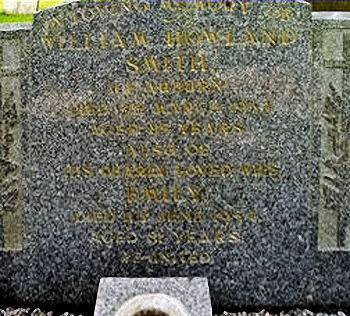
Their son Harry, who married Esther King in the fourth quarter of 1939 (GRO ref: Buckrose 9d 121), continued to farm Auburn Farm whilst his parents lived there in retirement. Right: William Howland Smith's headstone in Carnaby churchyard 2007 Source: Diane Witt family photograph |
 |
 |
In both census William gives his age to the decade, which does not correspond to his
stated birth date or his death record. William died 03 March 1954 (Will and GRO ref:
Buckrose 2a 21) aged 85 leaving £5543 4s 9d to Arthur William Henry Smith and Frank
Smith farmers. Emily died on 11 June 1954 (GRO ref: Buckrose 2a 22) leaving £549
to Harry Smith, farmer.
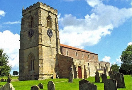
The couple were buried in Carnaby Churchyard. Left: Carnaby Church 2007 Source: Diane Witt family photograph |
With special thanks to Diane Witt, great niece of Emily and William Smith, for her information, comments, corrections and use of family photographs.
End notes
Sources:
| More information 1 |
 |
The Earl's Dike
|
| More information 2 |
|
RAF Lissett
Built in 1942 to Class A standard, Lissett was No. 4 Group's nearest operational airfield to the coast, being only two miles from the North Sea. Located six miles due east of Great Driffield town, on the east side of Grassmore Drain and the west side of the A165 Bridlington to Hull road, the site was formerly mostly meadowland. The runways were main 09-27 at 1,900 yards, 03-21 at 1,430 yards and 15-33 at 1,400 yards long.
As with several other No. 4 Group squadrons, No. 158 was transferred to Transport Command on May 7, 1945 when it prepared to convert to Stirling Vs. Once ready for its new role, the squadron was moved south to Stradishall and Lissett was relegated to care and maintenance status with a small caretaker detachment. This was withdrawn by the end of the year and eventually the whole airfield was abandoned. By the 1970s most of the concrete had been removed with the former technical site buildings used by small industrial firms and for farm storage, and at the end of the century little remains to indicate there ever was an airfield at Lissett. Source: Abandoned Forgotten & Little Known Airfields in Europe - Lissett (Accessed 01 April 2020) |
||||||||||
| More information 2 |
|
RAF Lissett continued
|
| More information 3 |
|
The National Farm Survey of 1941-43
The National Farm Survey (NFS) of England and Wales 1941-3, like the Valuation Office Survey of 1911, was dubbed a second Domesday survey, and provides a wealth of detail about farms, farmers and communities across the country, some 850 years after the first Domesday. The NFS went further than its 1911 precursor in identifying individuals working on the land, describing how they worked it and under what conditions. The NFS was carried out during the Second World War by central government. From the start of the war, Britain was faced with dire food shortages, with imports of fertilizers and foodstuffs drastically cut, so there was an urgent need for greater home food production. The area of land under cultivation had to be increased significantly and quickly. The Ministry of Agriculture and Fisheries (MAF) aimed to do this via County War Agricultural Executive Committees ('County War Ags'), who were given many powers. They could reclaim derelict land, requisition labour, tell farmers what to grow, inspect property and, in extreme cases of bad management, take possession of land. … A farm survey was made to assist the ploughing-up campaign, which extended to land that had not seen the plough since medieval or even prehistoric times (Ref: the film 'Land Girls'). Between June 1940 and the early months of 1941 all but the smallest farms were surveyed, and classified according to the physical condition of the land and productivity as A, B or C. Only summary statistics survive from this survey. Once the short-term objective of increasing food production had been achieved, a second survey was made with a longer-term goal, to inform post-war agricultural planning. This was the NFS, taken between spring 1941 and the end of 1943. It was envisaged as a permanent and comprehensive record of the conditions on the farms of England and Wales, although the thrust of the questions asked was still towards ensuring that the land was used for maximum output, and that it was managed efficiently. The NFS had a wide remit. It covered all agricultural areas of five acres and above in England and Wales: some 300,000 holdings. These ranged from large farms to market and hop- gardens, and applied to many smallholders such as bulb growers and domestic poultry- keepers, who might not have called themselves farmers. The records produced for the NFS provide a wealth of detailed information about mid- twentieth-century rural England and Wales, including tenure and size of farms, acreage farmed, herd and flock size, farm labour, standard and methods of farming, facilities (electricity/water), equipment, horses and (their replacement) tractors, and even weeds and pests. The Survey consisted of three elements for each farm:
Source: Beech G & Mitchell R, 'Maps for Family and Local History', The National Archives, Kew, 2004 pp.69-70 |
| More information 4 |
|
War Agricultural Executive Committee (War Ag)
When the Second World War began in September 1939, Britain was faced with an urgent need to increase home food production, as imports of food and fertilisers were drastically cut. The area of land under cultivation had to be increased significantly and quickly. Under Defence (General) Regulation 49 the Minister of Agriculture and Fisheries was empowered to set up County War Agricultural Executive Committees ('County War Ags') to which the authority to increase food production was delegated. The Committees had powers to direct what was grown, to take possession of land, to terminate tenancies, to inspect property, and to organise mobile groups of farm workers. Much of the day-to-day work of the Committees was executed by district committees and sub-committees while the Executive Committee itself maintained a general supervisory role. One of the first responsibilities of the County War Ags was to direct a ploughing-up campaign under which large expanses of grassland (in some areas land that had not seen the plough since medieval or even prehistoric times) were prepared for cultivation. The Ministry required an extra 840,00 tons (853480 tonnes) of wheat. To assist this campaign, a farm survey was initiated in June 1940 to increase food production. By the early months of 1941 some 85% of the agricultural area was surveyed - all but the smallest farms. Contentious questions determined how good the farming was. Farms were classified in terms of their productive state, A, B, or C; categories relating more to the physical condition of the land than to the managerial efficiency of the farmer. However, the ability of each farmer to play his part in the national food production plan was assessed. In cases of gross inefficiency or dereliction, the Committees took control of the land and organised the labour. The War Ag could take over ‘C’ rated farms forcing farmers to leave his land and accommodation. In all 2700 farms were wholly taken over and 10000 taken over in part. It was sensible to cooperate with the War Ag. Farmers had to impress the War Ag’s representatives by producing what was needed for the UK market. Milk was a priority as it was seen to be ‘nature’s most complete food’. An adequate supply of nutritious milk depended on the quality of cattle feed and this depended on the Ministries promotion of the new silage feed. Silage, the preserving of green crops at their most nutritious in a process resembling pickling, replaced imported feeds and the hay from newly ploughed grasslands. Fodder crops production increased by 33%. Calves were weaned early on to artificial milk, oats and swedes leaving the raw milk for human consumption. Pigs were culled because there was not enough fodder. However, Pig Clubs formed, feeding pigs on household waste. On the presentation of a licence to slaughter, in the presence of a police officer, half the pig went to the Government with the other half to Club members. Mobile cinemas and Government film encouraged farmers to keep up with the latest Government advice. In 1940 ‘Spring Offensive’ was one of 2000 films produced by the Ministry of Information, Others promoted the control of pests. In 1943 rats caused £25 million (equivalent to £685 million in 2005) of damage to crops and buildings and reduced production by 2 million ton (2,032,100 tonnes) of food. Hence, questions on the Farm Survey assessed the state of vermin on the farm. In 1941, with Russia joining the war, the War Ag doubled its efforts to supply Russian food convoys. Cheese and butter manufacturing was centralised in Ministry factories. Only sour milk could be used for the home production of cheese and butter and then only with special dispensation. In 1943, with farmer's stamina ebbing towards exhaustion and weariness, the Government demanded an extra for 1.3 billion gallons (5.909917000000 litres) of milk and 1 million tons (1016050 tonnes) of wheat. Other improvements took place. A Government scheme allowed farmers to hire machines and mechanical attachments to improve efficiency. The Vet dealt with common complaints such as mastitis, which lowered milk production and reduced the War Ag efficiency rating. Milk yields were carefully recorded, at approximately two gallons (9 litres) a day to impress the War Ag. Rabbits were bred with an established colony producing 24 pounds (11kg) of meat. Government grants were made available. Despite the introduction of tractors, working horses made a huge contribution. By 1945 there were 500,000 horses, twice the number of tractors. The central role of Government in agriculture made farming more demanding. Achieving a ‘B’ meant that the farm was 60% productive; a level achieved by William Howland SMITH. The War Ags were abolished in 1947. Sources:
|
 |
 |
 |
|
| This page was created by Richard Crompton and maintained by Chris Glass |
Version A11 Updated 04 August 2024 |
||